A CIA Spy Plane Crashed In Death Valley In 1952 And You Can Hike To It If You're Strong Enough

If a 16-ton CIA spy aircraft crashes into a mountainside amidst the pure-black inky darkness of night in Death Valley, does it make a sound? Over 70 years ago a mayday call came across the airwaves, "Mayday. Mayday. Mayday. This is Air Force 001 bailing out north of Barstow, California," before six men exited the twin-engine aircraft that had spontaneously become a single-engine aircraft. The plane rapidly became an unmanned aircraft, and piloted itself directly into the side of a ridge. Decades later and the twisted wreckage of the craft remains where it came to rest, now a permanent fixture of the vast and sprawling Death Valley National Park. If you're incredibly physically fit, have an uncompromised hiking CV, and have an entire day to kill, you can even hike up to see the aircraft, like this guy did.
The plane was part of a super secretive anti-communist joint task force between the Air Force and the Central Intelligence Agency. The craft needed to be stealthy and swift in order to "penetrate foreign borders for the specific purpose of infiltrating agents and equipment to countries friendly toward the United States, but who were under the control of Communist rulers." The 580th Air Resupply and Communications Wing flew its training missions between Southwest Idaho and San Diego, a 1,400-mile trip that cut directly across Death Valley. All six of the men onboard survived the jump to the ground, though two were injured on impact. The four in good condition hiked over five hours to the nearest town, and park rangers hiked up to rescue the other two.
Where is the plane?
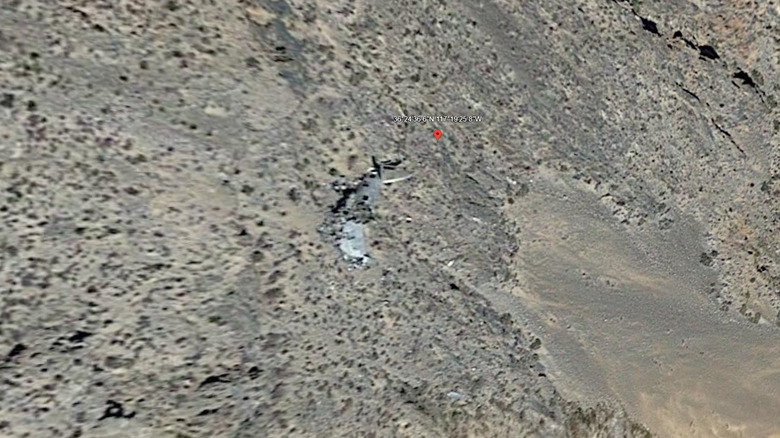
The wreckage of ARC Wing Grumman SA-16 Albatross Air Force 001 is visible from California Highway 190, and a couple hiking trails within Death Valley get you close enough to the plane to see it, but in order to actually get up close and personal with the craft you'll have to hike over 6,500 feet of elevation gain on some of the most dangerous terrain in the park. In order to get to the plane you need to hike up to the top of nearby Towne Peak, then descend for over an hour to reach the crash site. According to a hiker who visited the plane in 2007, "the final 150 feet to get to the plane is rather rough. It's a scree slope and you do have to be careful going down or you might really go down." If you're in really good shape you might be able to do this in a single day, but even many experienced hikers expect it to be a multi-day event.
I love hiking, weird transportation history, and our National Parks, but I think this one is beyond my skill level. I'll stick to the standard marked trails within the park, thank you very much. And if I was going to tackle this hike, I sure as hell wouldn't go alone. If you're inspired, good luck and Godspeed.